contenuti
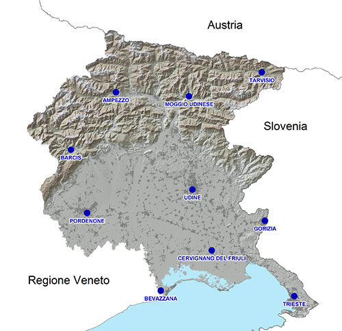
At the present time, the network is composed by ten permanent stations located throughout the
region and operating 24 hours a day, seven days a week; the choice of the locations of the ten
sites was evaluated on the basis of both technical-methodological and logistical criteria. Among
the technical and methodological requisites examined for evaluating the suitability of a site to
host a permanent station can be cited the absence of obstacles or electromagnetic disturbances that
could reduce the signal-to-noise ratio (SNR), the lack of possible sources of multipath
interference, the static reliability of the sites, and their geographical distribution for
obtaining an optimal coverage of the territory.
From a logistical point of view, it was decided to place the permanent GNSS stations at
peripheral offices of the Regional Administration in order to ensure direct accessibility to the
instrumentation, the continuity of electrical supply, and connection to the RUPAR regional
telematics network.

The instrumental characteristics of every permanent GNSS station are homogeneous and are guaranteed to function autonomously for 24 hours in the event of a mains power failure, utilising appropriate UPS.
|
Stazione |
Localizzazione | Inizio Operatività | Ricevitore | Antenna |
|---|---|---|---|---|
| Ampezzo | Stazione Forestale | 1999 | Leica GR25 | Choke Ring con Dome Sferico Leica AR25 |
| Barcis | Stazione Forestale | 2007 | Leica GR25 | Choke Ring con Dome Sferico Leica AR25 |
| Bevazzana | Consorzio Idrovia Litoranea Veneta e Diramazioni | 2007 | Leica GR25 | Choke Ring con Dome Sferico AR25 |
| Cervignano del Friuli |
Stazione Forestale |
2013 | Leica GR25 | Choke Ring con Dome Sferico Leica AR25 |
| Gorizia | Sede Regionale -
Via Roma |
2007 | Leica GR25 | Choke Ring con Dome Sferico AR20 |
| Pordenone | Sede Regionale -
Piazza Ospedale Vecchio |
2001 | Leica GR25 | Choke Ring con Dome Sferico Leica AR25 |
| Moggio Udinese | Stazione Forestale | 1999 | Leica GR25 | Choke Ring con Dome Sferico Leica AR25 |
| Tarvisio | Stazione Forestale | 2007 | Leica GR25 | Choke Ring con Dome Sferico Leica AR25 |
| Trieste** | Ispettorato forestale di Trieste e Gorizia- sede di Trieste via Cantù | 2016 | Leica GR25 | Choke Ring con Dome Sferico Leica AR25 |
| Udine | Sede Regionale -
Via Sabbadini |
2008 | Leica GR25 | Choke Ring con Dome Sferico Leica AR25 |
*The permanent station in Palmanova, located in the Contrada Savorgnan district, was in
operation from August 1999 to the 19th November 2012. The relative data can be requested by sending
an email to rete.gnss.marussi@regione.fvg.it (SupportoReteGPS).
**The permanent station in Trieste operated from the 26th May 2003 until the 23rd November
2016, at the regional office at 35 Via Monte San Gabriele. The relative data may be requested by
email
The control centre at the Regional Data Centre in Trieste has the following functions:
- monitoring of the activities of the permanent stations,
- management of the data streaming coming from the permanent stations, and the formatting of
files for post-processing differential correction,
- reception of signal for the real-time correction of the permanent stations, implementation
of VRS, MAC, and iMAC services, and their distribution via the internet utilising the Ntrip
Protocol,
- web server for access to RINEX files,
- Ntrip caster
The telematics connections between the permanent stations, the control centre, and the internet are made using the infrastructure of RUPAR (Unified Network for Regional Public Administrations).
The GNSS Network of the Autonomous Region Friuli Venezia Giulia "A. Marussi "is framed in the
national geodetic system called RDN ETRS89-ETRF2000 the day February 24, 2017.


 caricamento in corso...
